|
Making Mud of the Ancient Anacostia
EXTENSIVE MUDFLATS IN THE ANACOSTIA RIVER were pretty rare hundreds of years ago. Some tidal flats probably fringed the dense stands of vegetation, providing important habitat for certain shore birds and invertebrates. But based on historical maps and archival accounts, they were few and far between.
|
Hunters pole through wild rice in this 19th century image (top), searching for Sora rails, birds once abundant in Anacostia's marshes. The U.S. Army Corps of Engineers planned to remake the Anacostia River, as shown in a map from 1913 (bottom). The old channel (dotted lines) would disappear into a new lake, and in places the Corps would even fill the natural channel with dredged spoil. There would be a new, higher shoreline, and new islands, including Kingman Island (shown above as two islands on either side of Benning Road; the two eventually became one large island). A lock and dam system (never built) would control the lake level. In the end the river was neither natural nor controlled, and mud prevailed.
Engraving by E. Coues and D.W. Prentiss, 1883. 1913 Map by the U.S. Army Corps of Engineers. Click on the engraving or map to view a larger version. |
The Anacostia River was quite deep, some 40 feet in the channel, according to historian John Wennersten's book,
Anacostia: The Death and Life of an American River. It was navigable for ocean-going vessels all the way up to the port of Bladensburg in Maryland. Highway for communication and commerce, the river drove economic growth in the region beginning in the late 17th century — at a time when tobacco was king.
Tobacco, a fast-growing cash crop, thrived in the temperate climate and rich soil of the Chesapeake. Maryland was a big tobacco producer, and Prince George's County had more tobacco farms than any other county in the state. Farmers grew tobacco all along the shores of the Anacostia, and the port at Bladensburg shuttled it out to the Chesapeake Bay and the Atlantic Ocean beyond.
But with tobacco came the mass felling of the region's forests to clear land for farms and plantations. One plantation, the famed Montpelier in Prince George's County, claimed some 9,000 acres, likely once forestland, for fields, tobacco barns, stables, slave quarters, and one of the county's grandest mansions.
Cleared forests, construction debris, and weakened topsoil from continuous planting near the headwaters caused massive downstream silting of the Anacostia River. By 1762, just 20 years after the port at Bladensburg was first established, the docks were so heavily silted that the town held a lottery for "removing the shoals." By 1850 the port of Bladensburg was shut down. It had silted in completely, rendering it useless for any sort of shipping.
Meanwhile industry along the Anacostia continued to expand. The Navy Yard, along with housing and businesses, sprung up to support a growing population. Soon the Anacostia also became a dumping ground for sanitary sewage, an outcome dictated by complex racial politics in the District at the time.
By the end of the Civil War in 1865, outbreaks of cholera, smallpox, typhoid, and malaria had claimed thousands of lives, mostly African American. From an ecological standpoint, the combined impacts of siltation and development had basically turned much of the Anacostia to mud.
Though mudflats were becoming pervasive throughout the river system, the Kingman Marsh area remained relatively intact until the early 20th century. During this period, the U.S. Army Corps of Engineers began a large-scale dredging effort to reopen the historic shipping channel, in the process destroying most of the scant marshland that remained.
In 1916, the Corps deposited dredge spoils from the lower Anacostia on 160 acres of existing marshland to form Kingman Island (see A New Beginning for Kingman Island, p. 10). Between 1920 and the late 1940s, the Corps dredged the marshes surrounding Kingman Island to remove still more silt from the river and to control recurrent outbreaks of malaria. This dredging created Kingman Lake, which was intended as an outlet for recreational boating. But the lake began silting in immediately, filling with decades of deposited sediment from erosion in the watershed. Vast intertidal mudflats formed in the Kingman area, soon dominating the landscape at low tide.
By the late 1980s, the Anacostia River as a whole had lost 98 percent of its tidal wetlands and 75 percent of its freshwater wetlands, according to reports from the Anacostia Watershed Restoration Committee, part of the Washington Council of Governments. Sewage and toxic contamination were widespread, and the D.C. Council prohibited water contact sports like swimming, fishing, and boating.
Not until conditions had deteriorated to this point did efforts begin to rescue this "ruined river." The establishment of the Anacostia Watershed Society in 1987 and the leadership of its director, Robert Boone, former stream coordinator for the Interstate Commission on the Potomac River Basin, mounted the charge for restoration.
Dick Hammerschlag, who spent nearly his whole career working on the Anacostia as a biologist for the U.S. Geological Survey, remembers participating in planning charrettes in the 1980s with the Washington Council of Governments. A "germ of interest," he says, was stirring. The goal: remove mudflats and restore some of the ecological function of the Anacostia's historic wetlands.
— Erica Goldman
Read more about Wennersten's book at: www.mdsg.umd.edu/cq/v08n1/side6/
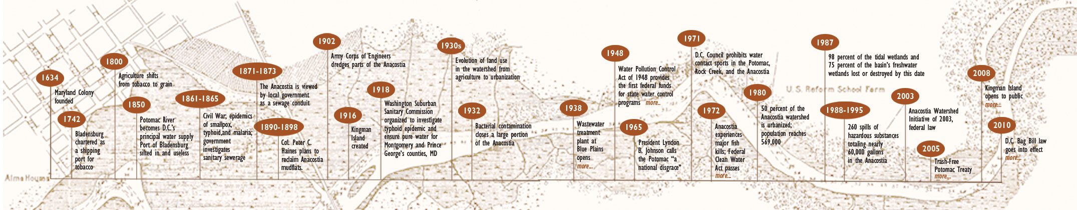
Anacostia River Chronology
Chronology adapted from The Anacostia River: The Death & Life of an American River by John Wennersten. Move your mouse over the left or right arrows to move though time. Click on entries with more... for more information. Click here to print the chronology.
|