|
Can an Engineered Island Help the Bay?
Jeffrey Brainard
An excavator looms over Poplar Island's Cell 5b. Dry soil shown here will eventually become a wet marshland filled with grasses. Credit: Jeffrey Brainard
THE BOAT IS CROWDED on a sunny fall morning as a dozen people scramble to find seats and strap on their life jackets. These passengers belong to the Baltimore Bird Club, and they are in a buoyant mood as the crew prepares for departure.
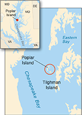
Today's travelers have lugged aboard camera bags, binoculars, and spotting scopes. They're excited because they are about to visit what has become a popular destination for birders — Poplar Island, just off Tilghman Island on Maryland's Eastern Shore. The boat that will take them there is the Terrapin, operated by the Maryland Environmental Service, a state agency that manages the island.
Also sitting on the boat is a scientist. Lorie Staver is a faculty research assistant and Ph.D. candidate at Horn Point Laboratory at the University of Maryland Center for Environmental Science. She's made this trip many times over the past decade. She is studying the marsh grasses growing on this new and unusual island. The vegetation provides habitat for many species of birds — least terns, ospreys, and snowy egrets — that the birders want to glimpse today.
The boat slips away from a dock at Knapps Narrows, and the engine revs up for the 20-minute ride to Poplar Island. A bald eagle flies over us as we approach. The island clearly doesn't look like others in the Bay. Its shore is an even, uniform strip of khaki tan. Yellow excavating machines dot its landscape. As we draw closer, we can see that the shores are piled with boulders.
Poplar Island is an artificial creation rising out of the Bay's waters, 3.5 miles long and a half-mile wide. The U.S. Army Corps of Engineers designed and built it in partnership with the state of Maryland. Starting in 1998, workers placed tons of sand and rock in a circle on the Bay's bottom. Then they began filling up the interior with sediment dredged from the Bay's shipping channels, a job that is still underway.
This massive feat of engineering — the largest of its kind in the United States — was conceived as a large-scale test of solutions to several challenges facing the Bay. One is to create enough storage space to contain all of the sediment dredged from the channels for years to come. The goal is to ensure that large cargo ships can continue to reach Baltimore Harbor to ply their valuable trade.
For more than a decade, Jan Reese has ridden a bicycle down the dusty dirt roads of Poplar Island year-round, at least once every two weeks. His mission: try to count every single bird on this 3.5-mile-long island and record its species name. more . .
Another challenge for the Bay is to prevent small, low-lying islands from being completely eaten away by erosion and drowned by rising sea level. Poplar Island had almost completely disappeared for these reasons when it was chosen for the restoration project.
Yet another challenge is to reverse the loss of natural marsh and wildlife habitat around the Bay. Poplar's contribution to that effort is to transform its acres of barren silt and clay into a natural landscape. Establishing marshes on Poplar is considered important for the overall project to succeed. And a decade into the experiment, Staver and her colleagues have found some interesting clues about how the marshes are faring in Poplar's unusual growing conditions. The plants look lush and green, but Staver says there is more to the story than these appearances.
"This is where the rubber meets the road in marsh restoration," says Court Stevenson, who is Staver's graduate adviser and a marsh ecologist at the Horn Point Laboratory. Given the money and effort put into the project, he says, "If we can't get it right here, it's not likely we're going to get it right somewhere else."
An Island Reborn
We arrive at the dock on Poplar Island as the sun rises higher in a cloudless blue sky. The birders head off for a bus that will ferry them to choice viewing spots around the island.
Lorie Staver exits the boat, loads a handcart with research gear, and wheels it across the island's hard-packed perimeter road to a pickup truck. She is petite, standing 5 foot 3 inches tall, but is plenty practiced at hauling equipment stands, duffle bags, even a metal dinghy on the island. She will use the truck today to ferry the gear and show me the research sites she is studying. We walk past the sign for the "Paul S. Sarbanes Ecosystem Restoration Project," naming the U.S. senator who helped to obtain federal funding for this $1.2-billion project.
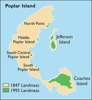
The project built up the remnants of the original Poplar Island that had nearly vanished. In 1847 a survey measured it at 1,140 acres. In the 1800s, it was home to 100 residents in a community called Valiant. But over time the island eroded into smaller pieces, and the residents moved away. Later, Presidents Franklin Roosevelt and Harry Truman took retreats at a hunting lodge built on a remnant, renamed Jefferson Island. But by the early 1990s, only about four acres of the original Poplar Island remained above water. Many other small, low-lying islands in the Bay have disappeared beneath its surface for the same reasons, erosion and rising sea level.
The Maryland Port Administration, working with the Corps of Engineers and other partners, picked Poplar as one island that could be saved. They needed a new sediment disposal site to replace one at Hart-Miller Island, near Baltimore Harbor, that was reaching capacity. Residents in and around Tilghman Island supported the choice, in part because scientists determined that sediments dredged from the navigation channels did not pose environmental or public-health risks.
In contrast to the Hart-Miller project, where the original goal was focused on sediment containment, the initial plan for Poplar called for the deliberate, "beneficial reuse" of the dredged sediment. That meant establishing nearly 600 acres of marshland and wildlife habitat across the rebuilt island, which measures 1,140 acres as it did in 1847.
The map on the top left illustrates how much Poplar Island shrank between the mid-19th century and 1993; the schematic on the top right shows the island's reconstruction plan. Marshes are being created in cells on the eastern half of the island. Visitors to Poplar Island are greeted by a sign at the exit of the island's dock. Credits: photograph and map sources, U.S. Army Corps of Engineers; map, iStockphoto.com/University of Texas Map Library
Poplar's rebirth is important because the Bay has lost more than half its acreage of marshlands since European settlement, and the loss continues today. Also missing are the many benefits that marshes provide. Tidal wetlands help to filter nutrients and sediment out of the water and improve water clarity. A healthy, established marsh can help shorelines resist erosion. And the open, offshore location of islands like Poplar offer nesting places and refuge from predators for dozens of species of shorebirds and waterfowl.
Lorie Staver has been coming to this island since 2003, when the Corps of Engineers completed the first wetland area. She and her colleagues at the Horn Point Laboratory are funded by the Maryland Environmental Service to study the marshes there. The managers of the habitat restoration at Poplar are tracking a variety of measures of progress in the effort. These include marsh size and waterbird populations on the island (see The Return of the Birds) and fish species and sea grasses in the waters around it.
"Poplar Island is a good place to learn about marsh ecology because it's a system that's been built from the ground up," she says. "And to build that sort of system, you have to understand how the natural system works."
Staver climbs up behind the wheel of the parked pickup truck. We're joined by her daughter, Charlotte, an undergraduate at the University of Maryland, who rode out with us today to help her mother take field measurements. Near the truck, we can see dense stands of marsh grasses growing. Staver starts the engine and begins our driving tour by heading for the island's south tip. "When we get to the end of the island," she says, "you'll see a real difference."
Scientists want to know how fast soil is building up on Poplar Island marshes from natural processes. Here a research team (above) is measuring soil height using a tool called a Surface Elevation Table. They attach it to a concrete tube permanently set into the marsh, allowing for consistent measurements over time. This natural marsh is located near Knapps Narrows on the Eastern Shore's mainland; the scientists want to compare figures recorded here to ones from Poplar Island. Daniel Stevenson (left) assists his father, Court Stevenson (right), and Lorie Staver (center), both researchers at the Horn Point Laboratory of the University of Maryland Center for Environmental Science. Credit: Jeffrey Brainard
Studying a New Habitat
We arrive and park on a dusty road on the island's rim. To our right are the waters of the Chesapeake Bay and rocks piled ten feet high to form the island's perimeter. To our left is a landscape that looks like a dry lake-bed out west. "Cell 5" is one of the last sections of the island to be filled in, and today it looks like it was hit by a bad drought. Staver walks out into the cell, surrounded by acres of cracked earth.
But this appearance is all part of the plan for Poplar. Cell 5 is one of 15 cells that the Corps of Engineers created by diking off the island's interior. Workers have progressively filled up each cell by pumping in dredged sediment from barges, which deliver about three million cubic yards of the stuff to the island annually. Think of it like filling a giant ice-cube tray with mud.
Now the engineers have left the sediment in Cell 5 to settle and dry before they begin the next steps to transform it into a wetland. Machine operators will grade the cell to a carefully pre-determined slope. That will let tides ebb and flow across the surface in a predictable way designed to deliver just enough water for the marshes to grow and persist. Each marsh cell is connected to the Bay via pipes running through the island's perimeter wall of rock and sand. These culvert pipes, set at sea level, will allow the tide to flow in and out.
To complete the cell, workers will plant hundreds of cordgrass plants (Spartina alterniflora and Spartina patens) in tidy rows during a single day. Eventually the entire eastern half of the island will be transformed into salt marsh. That, at least, is the plan.
As we leave Cell 5, we drive north, past a series of backhoes and dump trucks, and Staver points out a progression of constructed marsh cells of differing ages. They provide her and her colleagues a good research opportunity to measure how plants are growing in each cell and how well the marshes are doing over time.
Staver parks the truck and pauses the tour so she can record new data points to add to her long-standing record. She and Charlotte make their way down an embankment and into Cell 4d, completed in 2003, the oldest and most-mature marsh on the island. "This was the place we first started monitoring, the first place we saw plants take over," she says.
Staver has come back again and again to measure the marsh plants' height, always the same way. One by one, she finds a series of meter-tall markers set into the soil. At each marker, she finds the five tallest Spartina stems within a one-meter radius and uses a ruler to measure their height. Charlotte writes down each measurement on a clipboard. Later, Staver will average the measurements and compare them over time to study growth trends.
Staver calls off the centimeters: "81...77...89...74...71." One set of measurements down. Thirty-five more markers to go.
It's a lot of work. But it's a gorgeous, bright day, and Staver seems at home in the marsh. A botanist, she easily points out unusual plants other than the ubiquitous Spartina. Other species have begun to fill out and diversify the marsh cells. There's Pluchea, whose pink flowers give off a strong odor of camphor. Some people use it as an herbal remedy.
A young terrapin scuttles by our feet, another small sign that something like a normal ecosystem is becoming established here.
 Sections of Poplar Island look barren Sections of Poplar Island look barren before workers plant rows of marsh grasses in May (top, left). But by September, greenery is abundant as plants soak up the rich supply of nutrients present on the island (top, right). But nutrients also have a negative effect: after flourishing for several years, marsh plants experience "dieback," little or no growth for an entire growing season (bottom). Credits: Top, left and right, U.S. Fish and Wildlife Service; bottom, Jeffrey Brainard
But in many ways, these relatively new marshes are far different than those found in established, natural ecosystems. A big difference is age: it can take a big, natural marsh, like Blackwater National Wildlife Refuge on the Eastern Shore, more than 1,000 years to form. It's a slow-motion process where the plants grow, die, and decompose in tidal areas. The decomposed stalks and roots can become marsh soil, trapping mud and sand, and slowly a marsh can grow, higher and wider.
Poplar is not only much younger, but the dredge material used as soil is not what you'd find in a natural marsh. The material consists almost entirely of fine-grained sediments — clay and silt. These small particles are readily carried through the Bay and eventually settle in the Bay's deep navigation channels. In contrast, natural marshes rise up atop diverse sediments, including heavier sand grains; this material tends to settle to the bottom of the Bay in shallow areas close to shores and doesn't reach the deeper channels.
This matters for the marsh-restoration effort on Poplar because the fine-grained sediment deposited there dries hard and dense. That presents a challenge for the newly planted marsh plants. Their roots need oxygen to grow (which is why gardeners turn the soil in their backyards each year), but it's hard for oxygen to penetrate into this hard-packed soil, Staver explains. As we walk across another recently created section — Cell 1b — the jet-black surface is a bit slippery but much firmer than in natural marshes not far from Poplar Island, where you can take a single step and sink up to your hip in muck.
Poplar is also unusual because the dredged sediments are very high in nutrients, like nitrogen and phosphorus. The concentrations are up to 100 times what you would find in the soil of natural marshes, Staver says. That's because as the sediments lay at the Bay's bottom before they were dredged, they were steeped in a rich brew of these nutrients from a variety of human and natural sources. These include farms, sewage treatment plants, and stormwater drainage pipes, among other sources.
"You have a whole ecosystem [on Poplar Island] that has this rich supply of nitrogen," Staver says. "So I think that's part of the value of this monitoring project.... What does a marsh system that gets exposed to these high nitrogen concentrations do over the long term?"
During the next 10 to 15 years, the young, growing marsh plants will consume nitrogen and phosphorus, and the nutrient levels in the sediments will decline and approach the lower ones observed in natural marshes, she says. For now, the high level of nutrients on Poplar provide abundant fertilizer for the plants.
But, Staver's research indicates, that abundance can be too much of a good thing.
Jeffrey Cornwell, a biogeochemist at the Horn Point Laboratory (left), works to set a porewater equilibrator down into the marsh’s muck. Cornwell is studying how the chemistry of Poplar’s marshes is changing over time. He wants to know whether they will, on balance, store nitrogen or release it over time to the Bay. Scientist Lorie Staver (right) stands on the cracked ground of Cell 5, where dredged sediments have been left to dry. Credits: left, Jeffrey Brainard, right, Michael Fincham
Extremes in the Environment
The high nutrients and the packed soil make "a fairly harsh environment," Staver says. But places like this tend to interest and draw ecologists and other biologists. She admires another ecologist, the late Scott Nixon of the University of Rhode Island, who wrote that such environments existed at "the borders of what is possible for life.... Perhaps where life is pressed to its limits, it is pared to its essentials, and the basic nature of the ecosystem is more accessible to our understanding."
Staver gazes out over a marsh cell and says, "It really struck me, that's the way I think of this place.... I think you learn the most about an ecosystem when it is under stress. To me that's the most interesting part of the marsh out here, is how the system responds."
She has been able to make so many repeat trips here because she has been working for years for her doctorate in environmental science at a slower pace than many Ph.D. students. Staver pursued graduate studies in Maryland in the 1980s, then took time off to raise three children with her husband, Ken, also a scientist. But she held on to her goal of completing her degree one day, and for the past decade she has focused her dissertation work on Poplar Island. She expects to defend her thesis in 2014.
Despite living in this extreme environment, many of the Spartina plants we see look like they are thriving. As a demonstration, Charlotte Staver (who is taller than her mother) walks into a stand of the plants — and disappears. The plants are about six feet tall. In natural marshes, they would measure closer to three or four feet. Charlotte walks back and rejoins us in the truck with a grin.
But after the initial lush growth at Poplar, things change. In a number of cells, the tall plants have fallen over during the growing season, a phenomenon called "lodging."
Staver suspects that this may be caused by the high nutrient levels. The Spartina plants grow so tall so fast that their stems and stalks are too long to stay upright in heavy wind. Unchecked, the lodging may interfere with the marsh plants' normal metabolism, Staver says. During the following year's growing season, many marshes containing plants that lodged have shown extensive "dieback" — persistent, large patches of brown. These plants didn't put up new shoots. The lodging may have reduced the plants' ability to transfer oxygen down to their roots and rhizomes buried in the oxygen-poor sediment, according to Staver.
"Lodging" isn't unique to Spartina — it has also been observed in agricultural crop plants exposed to high nutrients in fertilizer. But crop scientists have selectively bred crop plants to resist lodging. The Spartina plants on Poplar weren't bred that way. So Staver and her colleagues are conducting an experiment to see if they can reduce the lodging by fertilizing the plants with a soil treatment high in silicate, a compound that helps grasses and other plants to form rigid stems and stalks. The gray, granular fertilizer is something like taking calcium supplements to keep your bones strong.
Even without silicate treatments, the marshes that show dieback don't remain brown for long. By the following summer, many of these cells have rebounded with green growth. But then these same cells have undergone subsequent diebacks. Scientists have seen boom-and-bust cycles like this in natural marshes but not to the extent seen on Poplar, Staver says. These extreme fluctuations in growth may reduce the marshes' long-term prospects for survival, she says.
A Race Against Sea Level
Staver and her colleagues have also studied another kind of upward growth. The marshes' soil level is rising vertically, and scientists want to know whether it is rising fast enough to keep pace with the rising sea level of the Chesapeake Bay. In an expanding marsh, it is not only the plants that grow upward. The soil they sit on also accumulates, raising the entire marsh.
The researchers' preliminary finding is that the soil in three of the longest-established cells on Poplar Island is indeed rising at a healthy clip. The scientists studied three cells completed in 2005, 2009, and 2011. The increase there averaged around one centimeter, or roughly a half-inch, per year. That is more than double the rate of sea level rise recorded in the Chesapeake Bay during the past century. And it is on par with increases observed in natural, mature marshes located elsewhere at the Bay's edge.
"I was very surprised that there was as much accretion as there is" at Poplar, Staver says. "At first, I said, this can't be right." But the results were double-checked, and they were confirmed.
Although the finding seems like good news for Poplar's future, there's a problem — sea level rise in the Bay has accelerated since the early 1990s. And sea level is projected to increase by about two feet between 2000 and 2050, according to the latest scientific estimate. If marsh plants are flooded with too much water too often, they can drown and die. And if the Bay rises faster than the marshes, the eastern half of Poplar Island could become a tidal pond hemmed in by the island's rock perimeter. Staver and her colleagues will continue to monitor and worry about this race between the marshes and the Bay.
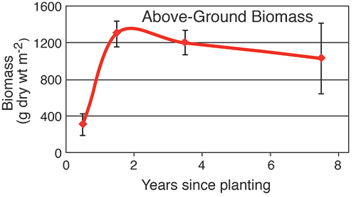
Changes on Poplar Island aren't occurring only above ground. Something good is happening below. To put it simply, the marsh plants measured by Staver are starting to grow bigger roots. That's important because they help marsh plants stay anchored and resist being washed away by tides, storms, and winds.
Over time, in marshes on Poplar Island, plant biomass below ground and soil elevation have slowly increased — good signs for the marshes' future progress and survival. Figures for biomass are averages based on plant matter collected from sample sites at the end of each year's growing season. Graph source: Data courtesy of Lorie Staver
This stability is notable because recent research in Louisiana and other locations indicates that chronically high levels of nitrogen can actually harm mature natural marshes by reducing the size of the plants' roots. Staver and her colleagues wanted to find out if the newly planted marsh grasses at Poplar Island were responding in a similar way.
"The old paradigm was that marshes can act sort of like a sponge to take up nutrients, that they can take up a tremendous amount of nitrogen and phosphorus," Staver says. "And they can do that without too many negative effects." But the new research from other states indicated that negative effects were occurring, below the ground.
Finding out the effects of high nitrogen on the Poplar marshes required labor-intensive work. Staver has raked up plant stalks and stems in test areas of the marsh in the fall, at the end of the growing season. She dried this above-ground biomass and weighed it. She also dug up roots and rhizomes to a depth of 25 centimeters and took the same steps to weigh them.
Staver found that when the marshes were first created, the amount of below-ground biomass — the anchoring root material — was relatively small. With access to abundant nutrients in the soil, the plants weren't forced to devote their energy or biomass to growing big, long roots to suck up the nutrients.
But as nitrogen levels have declined, below-ground biomass in the older marsh cells has increased while above-ground biomass appears to have leveled off, Staver's evidence indicates. Over all, the ratio of below- to above-ground biomass in Poplar marshes remains abnormally low compared with this ratio in natural marshes. But the balance on Poplar appears to be shifting in favor of the plant roots. Bigger root structures may improve the prospects that the marsh will remain stable and survive the forces of erosion, she says.
That's promising news not only for Poplar Island marshes but those elsewhere in the Chesapeake. Efforts are underway Baywide to reduce the excess nutrients contained, for example, in outflows from sewage-treatment plants. If that work succeeds and nutrient levels drop significantly across the estuary, natural marshes may respond favorably, growing bigger root systems fairly quickly, Staver says.
"Controlling or reducing nutrient inputs to an impacted marsh should yield a response within just a few years," she says. "And that's good news in terms of building the sediment elevation so that the marsh is keeping up with sea level rise."
The Long Haul
The research on these marshes should help inform similar projects elsewhere that involve dredging sediment or restoring wetlands or both, says Jeffrey Cornwell, a biogeochemist at Horn Point Laboratory who is a co-principal investigator with Court Stevenson on the Poplar marsh research. "[The results] are going to be guidance for people from all coasts in the U.S. that have to dredge fine-grained materials and find something to do with them," he says. "Nationally and internationally, there's a tremendous interest in the effect of high nutrients on marsh functioning, and in particular how marshes keep up with sea level rise."
"It looks like a lot of the other marshes I walk through" elsewhere around the Chesapeake Bay, says researcher Jeffrey Cornwell about cordgrass (Spartina alterniflora) on Poplar Island. Grasses are planted in small rows, at first resembling fields of crops. But eventually the marshes fill in and become more natural looking. Cornwell and other colleagues are studying the pace of that transformation. Credit: Jeffrey Brainard
The research findings by Staver and her colleagues promise to help inform future management efforts on Poplar Island, says Mark Mendelsohn, a biologist in the Baltimore office of the Corps of Engineers who has participated in the project since its inception.
Poplar Island could continue to receive dredged sediment for years to come. Its current storage capacity is expected to be reached by 2019. But the Corps of Engineers has sought federal funds to expand the island by an additional 575 acres, which could extend the facility's capacity until 2029.
The Corps and Maryland Port Administration have considered other sites for additional disposal once the Poplar project is finished. Candidates include James Island and Barren Island, located to the south of Poplar, which have shrunk because of erosion. So far no new sites have been chosen.
As shorebirds fly overhead on Poplar Island, Staver packs up her gear for the return trip on the Terrapin. Evaluating the success of the marshes on the island could take decades, she notes. Studies in Maryland and elsewhere have found that some projects to restore wetlands have not succeeded because they were not designed and managed adequately and for long enough. Here on Poplar, the management effort is active and is planned to last longer than in typical restoration projects. The Maryland Environmental Service plans to continue monitoring the marshes and wildlife until the project's expected conclusion in 2041.
For now, there's a lot more to learn about how to help newly planted marshes persist. "It's not that the marshes here are not successful," Staver says, "but they are different from natural marshes."
Staver joins the boatload of satisfied birders as the Terrapin pulls away from the dock for the trip back to Tilghman Island. One sure bet is that she will be back to continue to study those differences.
|