|
The View from Above
|
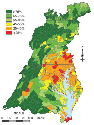
A patchwork of watersheds knits together to create the Chesapeake drainage basin. Dark green denotes watersheds still heavily forested in 2000. Stephen Prince and his colleagues use satellite imagery to track changes in land cover, including forest cover and impervious surfaces.
Source: Mid-Atlantic Regional Earth Science Application Center. |
WHEN IT COMES TO FORESTS, STEPHEN PRINCE TAKES THE LONG VIEW. And the high view — usually about 400 miles up or more. That's the altitude range for polar orbiting satellites like Landsat. The big picture comes in handy when trying to get a handle on the whole Chesapeake Bay watershed — a 41-million-acre chunk of real estate that stretches from the soggy marshlands of the Eastern Shore to the flinty highlands of West Virginia and Pennsylvania.
Today Prince sits in front of two large computer screens, looking at the satellite image of a small patch of woods. Students wait outside his office door. For more than 20 years he's studied the region's landscape and taught geography at the University of Maryland, College Park.
Prince and his colleagues produce maps that show where the forests are, and where they aren't. One map breaks this down by sub-watershed, using color codes (see map at right). Dark green shows watersheds at least 75 percent forested — where most experts agree that streams have a good shot at ecosystem health. Much of that dark green is confined to the western reaches of Virginia, West Virginia, and Pennsylvania.
As the map moves toward the metropolitan areas of Philadelphia, Baltimore, Washington, Richmond, and Norfolk, forest cover drops to less than 45 percent and then even less than 25 percent. Along the suburban fringe, where development and forests collide, battles over trees can be fierce.
One of those battles has come to College Park, not far from where Prince now sits. The image on his screen is of a threatened forest right across campus.
Lying alongside busy University Boulevard, this small forest patch looks a little beaten up. A deadly tornado ripped through in 2001, twisting tree trunks and breaking branches. According to campus experts, these woods offer a chance to document how a small forest can come back from such insults.
Prince refers to this 22-acre patch of forest as "the wooded hillock." It's become a bone of contention, sparking articles not only in the student paper but in the Washington Post and the Baltimore Sun. Campus planners want to bulldoze almost half the woods so they can move maintenance facilities and a parking lot away from Route 1, an area designated for more upscale development.
Students are upset about losing the woods. And so are faculty.
Prince, whose accent reveals his roots in the United Kingdom, speaks with some heat. He says that the woods serve as an outdoor classroom for some 1,300 students a year who study biology and the environment. He feels that taking down the woods doesn't fit well with a recent campus-wide emphasis on sustainability or with pledges to preserve natural environments. It doesn't help to green the University's image.
And he thinks the trees play an important ecological role. He points to the image on the computer screen. There a green triangle reaches from one patch of woods to another.
Prince says it's the last remaining connection between the riparian forests along the Northwest Branch and those of the Northeast Branch — tributaries of the Anacostia and therefore of the Potomac River. Ecologists call these woodland connections "corridors." And if the trees of the wooded hillock come down, that natural corridor will close.
This battle has special significance for Prince. His academic training is in plant ecophysiology — he studies and teaches the relationship between plants, landscapes, and ecosystems. He uses models with names like "Sparrow" to estimate the impact of impervious surfaces. He estimates the amount of runoff that comes from developed landscapes, and the amount of nitrogen and phosphorus that flows down streams and rivers into the Chesapeake Bay.
Though nothing like the vast reaches of forest in the Bay's western watershed, the wooded hillock plays its part in slowing runoff, absorbing nutrients, and providing a wildlife corridor — the last living connection between the two arms of the Anacostia. As development spreads through the suburbs, it's not the only wooded corridor that's closing.
— Jack Greer
|